
Forecasters have slapped a yellow weather warning for ice across the whole of Kent, as a stubborn Arctic air mass refuses to budge.
The 10-hour alert, covering every corner of the county, kicked in at midnight and is set to run until 10:00 GMT on Wednesday. Meteorologists say that as rain and sleet clear out overnight, damp surfaces will quickly turn into “skating rinks,” creating hazardous patches on roads, pavements, and cycle paths that haven’t been treated.
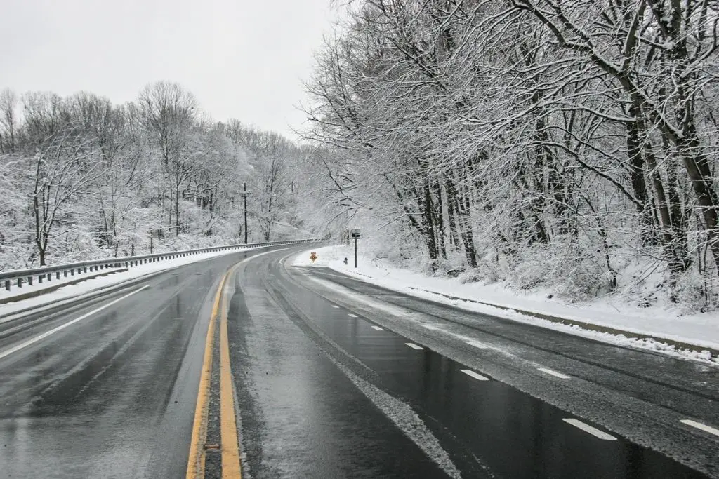
Commuters braced for a “treacherous” Wednesday morning
The biggest headache for the morning rush will likely be “black ice” – that thin, invisible layer that catches even the most careful drivers off guard. Kent Police and National Highways have already been out with early warnings, telling motorists to ditch the shortcuts and stick to main roads.
“This isn’t just a light frost; we are seeing Arctic air and northerly winds really gripping the UK right now,” noted Met Office Deputy Chief Forecaster Mark Sidaway. He cautioned that while some areas look clear, “wintry hazards” are bubbling up across the South East.
It isn’t just the roads causing concern. Southeastern and Southern rail passengers are being told to double-check their apps before leaving the house. Ice on the “third rail” – the strip that gives electric trains their power – can cause arcing and sudden stalls, a common culprit for morning cancellations in Kent.
Health alert pushed back to Sunday
The biting cold has forced the UK Health Security Agency (UKHSA) to tear up their original timeline. They have now extended the Amber Cold Health Alert for the South East until midday on Sunday, 11 January.
An amber alert is a serious signal. It means the weather is expected to hit the entire health and social care system hard. Dr Agostinho Sousa, who leads on extreme events at the UKHSA, warned that these plunging temperatures are a “serious risk” to the vulnerable.
“Cold like this can trigger heart attacks, strokes, and nasty chest infections,” Dr Sousa said. He urged Kent residents to keep an eye on elderly neighbours or anyone with long-term health issues who might be struggling to keep their homes warm.
Gritting crews out on the “primary routes”
Kent County Council (KCC) hasn’t been idle. Their fleet of 64 gritters has been working through the night, covering about a third of the county’s total road network. These “primary routes” are the A and B roads that keep the county’s heart beating, including links to hospitals and fire stations.
However, KCC Highways issued a blunt reminder: salt isn’t a silver bullet. Once the road surface hits -6°C, the grit loses its bite. While big arteries like the M20 and A2 should stay clear, many residential cul-de-sacs will be left untreated and potentially very slick.
When will we see a thaw?
Don’t expect to lose the winter coat just yet. Forecasters think these “teeth-chattering” lows are here for the long haul this week. Some northern parts of Kent have seen the mercury hit -5°C overnight, and daytime highs aren’t exactly tropical, struggling to get past 3°C.
The weekend forecast is still anyone’s guess. There is a battle going on between milder Atlantic air and this cold block. If that moisture manages to barge in, it could collide with the freezing air over Kent and dump a fresh layer of sleet or snow.
How to stay upright in the freeze
Emergency teams have put out a quick checklist for anyone heading out:
- In the car: Clear your windscreen properly—don’t just “porthole.” Keep a blanket and a torch in the boot just in case.
- On your feet: Wear shoes with a decent tread. Avoid shaded paths where the sun never hits, as ice there can linger all day.
- At home: Health teams say try to keep your main living space at 18°C if you can.
School watch
While most headteachers are planning for business as usual, the final call often comes down to staff safety and whether the playground is a slip hazard. Parents should keep their phones close for “Kent Closures” alerts or school texts first thing in the morning.