
DOVER, KENT – June 14, 2025 – Kent has been left reeling after a catastrophic thunderstorm swept through on Friday evening, June 13, 2025. This storm came right after the year’s warmest day, and the Met Office had already issued an amber warning, signaling its intensity.
Dover Bears the Brunt of the Deluge
Dover took a beating from the storm. Floodwaters rose rapidly along Folkestone Road and Maison Dieu Road, overwhelming emergency services with calls.
Water crept several feet into homes, ruining electronics, furniture, and personal items. All night long, Kent Fire and Rescue Service, volunteers, and other groups worked incessantly. They handed out essential supplies, conducted welfare checks, and drained water from flooded buildings.
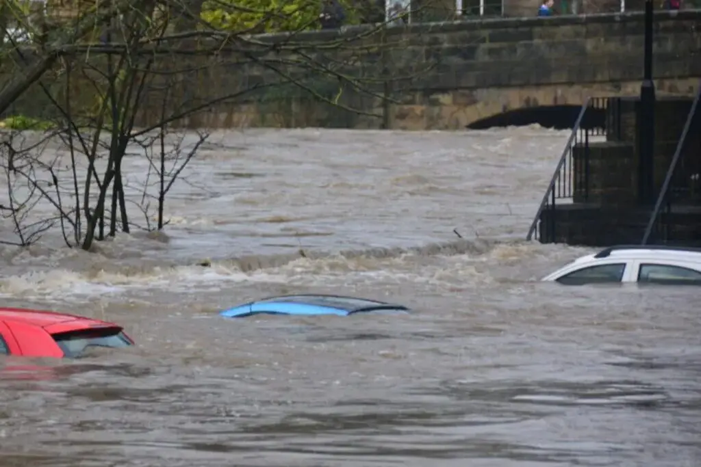
About twenty-one people had to leave their homes and find temporary shelter in nearby community centers. The whole area lost power. People on social media shared pictures and videos of flooded homes and cars underwater. Worries also came up about sewage leaking into the sea because of storm overflows.
Transport Chaos and Infrastructure Strain
Kent’s transport networks were severely affected.
- Roads: Flooding shut down the A256 in Tilmanstone and the Sandwich Bypass. Someone snapped a photo of a driver stuck on their car roof waiting to be saved. The police told people not to travel unless they had to.
- Public Transport: Stagecoach stopped running buses between Dover and Canterbury. Water on the roads and landslides caused big delays and cancellations on train lines all over.
- Wider Impact: The weather messed with air traffic control, leading to flight delays at Heathrow Airport.
Official Warnings and Ongoing Concerns
The Met Office has put an amber alert in place from 20:00 BST on Friday to five hours past midnight. This warning suggests that there is a danger to life and could lead to travel delays, road and rail closures, power cuts in some areaareas,s with the risk of dangerous floods water,s the presence of lightning, and hail winds, which have been given the yellow warning.
The Environment Agency’s flood duty manager Katharine Smith, warned of the potential for “large, and possibly quite an intense amount” of surface water. EA (Environmental Agency) teams also removed debris from rivers and watercourses, supporting local authorities. Smith urged people not to drive through floodwaters, saying just 30 cm of flowing water can float a car. FIVE flood warnings and 49 flood alerts are in place on Friday.
Yellow thunderstorm alerts are also still in place for parts of northnorthern England and Scotland until Saturday morning. 10 to 20 with local rainfall in the amount of rain reaching occasionally 30-50 (locally a possible – from the southwest up to approximately about 80) mm.
Steve Ramsdale, Chief Meteorologist at the Met Office, said: This warning has been updated to include a larger area and will be in place for longer as further storms are expected from late Friday afternoon; not all places will see thes,e but where they happen there could be significant impacts. There will be a return to more settled weather across the South East during Saturday as heavy showers and thunderstorms ease. Right now, the priority is to get back up and analyze the wreckage.